Tamriel Map
Every province of the Elder Scrolls continent, with capitals, cities and the games set in each.
Tap a province to learn about it. Drag to move, pinch or scroll to zoom.
The nine provinces of Tamriel
Tamriel has been divided into nine provinces for most of its history. Each is the homeland of one of the playable races.
Skyrim
Nords
Tamriel's northernmost province, a land of snowfields, pine forests and high peaks. Home of the Nords and the setting of The Elder Scrolls V: Skyrim.
Morrowind
Dunmer (Dark Elves)
The north-eastern homeland of the Dunmer, built around the island of Vvardenfell and the volcano Red Mountain. Setting of The Elder Scrolls III: Morrowind.
Cyrodiil
Imperials
The largest province, at the centre of the continent, home of the Imperials and the Imperial City on Lake Rumare. Setting of The Elder Scrolls IV: Oblivion.
Hammerfell
Redguards
A dry western province of deserts, mountains and ports, home of the Redguards. Its shore on the Iliac Bay was part of the world of Daggerfall.
High Rock
Bretons
The north-western province of the Bretons, divided into many small, rival kingdoms. Its Iliac Bay coast was the setting of The Elder Scrolls II: Daggerfall.
Black Marsh
Argonians
A vast south-eastern swamp and jungle, home of the Argonians and the sentient Hist trees. Outsiders rarely travel far beyond its borders.
Elsweyr
Khajiit
The southern homeland of the Khajiit, with dry badlands in the north and tropical jungle in the south. The source of moon sugar.
Valenwood
Bosmer (Wood Elves)
A south-western rainforest of giant trees, home of the Bosmer, or Wood Elves, who live under the strict Green Pact.
Summerset Isles
Altmer (High Elves)
An archipelago off the south-western coast, homeland of the Altmer, or High Elves, and seat of the Thalmor. Called Alinor in the Fourth Era.
Which Elder Scrolls game is set where
Use the game filter on the map to light up these regions.
- 1994
The Elder Scrolls: Arena
The whole continent, with cities in all nine provinces.
- 1996
The Elder Scrolls II: Daggerfall
The Iliac Bay region of High Rock and Hammerfell, on a famously huge map.
- 1998
The Elder Scrolls Adventures: Redguard
The island of Stros M'Kai, off the southern coast of Hammerfell.
- 2002
The Elder Scrolls III: Morrowind
The island of Vvardenfell, plus Mournhold and Solstheim in its expansions.
- 2006
The Elder Scrolls IV: Oblivion
Cyrodiil, the Imperial heartland, during the Oblivion Crisis. Remastered in 2025.
- 2011
The Elder Scrolls V: Skyrim
All nine holds of Skyrim, plus Solstheim in the Dragonborn add-on.
- 2014
The Elder Scrolls Online
Zones in all nine provinces, set nearly a thousand years before Skyrim.
A complete guide to the Tamriel map
Tamriel is the continent where almost every Elder Scrolls game takes place. This guide explains how to read the map above, which race lives where, how the provinces relate to Skyrim, Oblivion and The Elder Scrolls Online, and how to use the map for your own projects.
How to use this interactive Tamriel map
The map at the top of this page is a full Tamriel map that you can explore like a real atlas. Drag to move around, scroll or pinch to zoom, and tap any province to see its capital, people, neighbours and the games set there. City names appear as you zoom in, so the overview stays readable while the close-up shows every town from Solitude to Lilmoth.
Use the search box to jump straight to a province or city, even if you type it in another language. The game filter lights up the provinces of a single title, which is the quickest way to see where Arena, Daggerfall, Morrowind, Oblivion, Skyrim or ESO take place. When you have the view you want, the download button saves it as a PNG image or an SVG file, and every view has its own link that you can share.
The full Tamriel map: nine provinces at a glance
Tamriel sits on the planet Nirn and has been divided into nine provinces for most of its recorded history. Reading the Elder Scrolls Tamriel map from the north and turning clockwise, you meet Skyrim along the icy Sea of Ghosts, Morrowind in the volcanic north-east, the swamps of Black Marsh in the south-east, the badlands and jungles of Elsweyr in the south, the rainforests of Valenwood in the south-west and the Summerset Isles just off the coast. Hammerfell's deserts fill the west, the green hills of High Rock lie in the north-west, and Cyrodiil, the Imperial heartland, holds the centre.
Borders moved many times across the eras, and even the games do not always agree on the details. This map shows the provinces roughly as they appear around the late Third and early Fourth Era, the period of Oblivion and Skyrim. Distances are approximate, so treat it as a guide to where things are rather than a surveyor's chart.
Tamriel map and races: who lives where
Each province is the homeland of one of the playable races, which is why a Tamriel map with races is so useful when you create a character:
- Skyrim: the Nords, a hardy human people descended from settlers of Atmora.
- Morrowind: the Dunmer, or Dark Elves, long ruled by the Great Houses and the Tribunal.
- Cyrodiil: the Imperials, who have governed the Empire from the Imperial City.
- Hammerfell: the Redguards, warriors whose ancestors sailed from the sunken continent of Yokuda.
- High Rock: the Bretons, gifted with magic, and the Orcs of Orsinium in the Wrothgarian Mountains.
- Black Marsh: the Argonians, bound to the ancient Hist trees.
- Elsweyr: the Khajiit, whose forms follow the phases of the two moons.
- Valenwood: the Bosmer, or Wood Elves, who live by the Green Pact.
- Summerset Isles: the Altmer, or High Elves, home of the Thalmor.
SkyrimMorrowindCyrodiilHammerfellHigh RockBlack MarshElsweyrValenwoodSummerset Isles
Skyrim, Cyrodiil and High Rock on the Tamriel map
Most visitors arrive looking for a Skyrim Tamriel map, so start there. Skyrim is the northernmost province of Tamriel, walled off from Cyrodiil by the Jerall Mountains and from Morrowind by the Velothi Mountains, with High Rock and Hammerfell to the west. Its nine holds, from Solitude in Haafingar to Riften in the Rift, are marked on the map and described in the Skyrim guide.
Cyrodiil is the largest province and borders six of the other eight, which is why the Imperial City on Lake Rumare has been the capital of Tamriel for so long. High Rock, on the other hand, is a patchwork of rival Breton kingdoms such as Daggerfall and Wayrest around the Iliac Bay, the region explored in The Elder Scrolls II: Daggerfall. Each of these provinces has its own page with a focused map, its cities and a short history.
ESO Tamriel map: where The Elder Scrolls Online takes place
The Elder Scrolls Online is the only game that lets you visit every province, so many players look for an ESO Tamriel map to understand how its zones fit together. ESO is set in 2E 582, about a thousand years before Skyrim, when three alliances fought over the Ruby Throne: the Daggerfall Covenant of High Rock, Hammerfell and Orsinium, the Ebonheart Pact of eastern Skyrim, Morrowind and Black Marsh, and the Aldmeri Dominion of the Summerset Isles, Valenwood and Elsweyr. Cyrodiil, in the middle, is the open war zone.
Choose ESO in the game filter to highlight the whole Elder Scrolls Online Tamriel map, and open any province guide to see which ESO zones lie inside it, such as Glenumbra, Stonefalls, Grahtwood or Vvardenfell.
Tamriel and Nirn: the wider world
Tamriel is only one part of Nirn, the world of The Elder Scrolls. Lore describes other lands beyond its seas: Atmora to the north, the ancestral home of the Nords; Akavir to the east, home of the Tsaesci and the Ka Po' Tun; Yokuda to the west, which sank into the ocean; and Pyandonea, the island realm of the Maormer, to the south-west. None of these have been fully mapped in the games, so a Nirn map is mostly a matter of interpretation, while the Tamriel map above stays close to what the games actually show.
A detailed Tamriel map poster, wallpaper or background
If you want a detailed Tamriel map for your wall or desktop, the painted map page offers the whole continent as a hand-painted style artwork in 3686 by 3045 pixels, free to download. It contains no labels, which makes it a clean background for streams, videos and wallpapers, and it is sharp enough for an A2 Elder Scrolls Tamriel map poster. The interactive map can also be exported with names and borders when you need a labelled version.
Using the map for Minecraft builds, mods and campaigns
Builders who recreate Tamriel in Minecraft or other sandbox games often start from a top-down reference with clear coastlines and mountain ranges. The painted map and the SVG export work well as that reference layer, and the province borders help you plan where each region begins. Roleplay groups, tabletop campaigns and mod authors use the same files to show where a story takes place. You are welcome to use them in non-commercial fan projects as long as the tamrielmap.com credit stays visible.
- Provinces
- 9
- Cities
- 74
- Games
- 7
Painted map of Tamriel
The whole continent as an antique watercolor atlas. Zoom in to explore the terrain.
Painted Map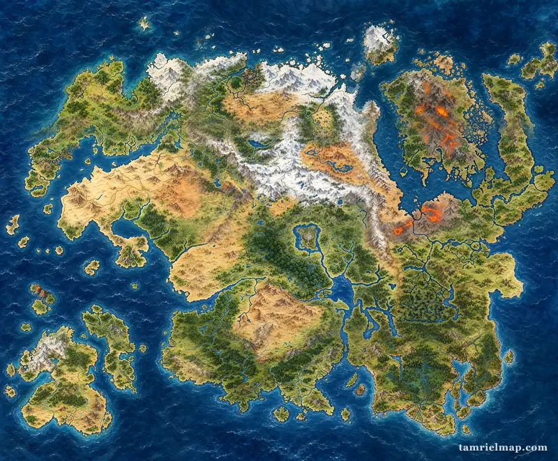
Questions about the map of Tamriel
Where is Tamriel on the Skyrim map?
Tamriel is not a place on the Skyrim map: it is the whole continent, and Skyrim is one of its nine provinces. The world map in The Elder Scrolls V: Skyrim only shows the province of Skyrim, which lies in the far north of Tamriel. The interactive map on this page shows where Skyrim sits within the rest of the continent.
Can you see the rest of Tamriel on the map in Skyrim?
No. The in-game map stops at the mountains that ring Skyrim. Beyond the Jerall Mountains south of Falkreath and Riften lies Cyrodiil, beyond the Velothi Mountains east of Windhelm lies Morrowind, and west of Markarth and the Reach lie High Rock and Hammerfell. Solstheim, an island in the Sea of Ghosts, appears in the Dragonborn add-on.
How big is the Tamriel Unlimited map?
Tamriel Unlimited is the full name of The Elder Scrolls Online, and its map is by far the largest of any Elder Scrolls game. Instead of one seamless province it has dozens of zones spread across all nine provinces, joined by wayshrines and boats, and new zones are still added with each chapter. Even so, it covers only part of Tamriel, not every corner of the continent.
Is all of Tamriel playable in ESO Tamriel Unlimited?
Not all of it. The Elder Scrolls Online has zones in every province, but large areas remain unexplored, such as the heart of Black Marsh, southern Hammerfell around Taneth and Rihad, and the smaller islands of the Summerset archipelago. Choose ESO in the game filter above to see which provinces the game reaches.
What is Tamriel?
Tamriel is the continent where The Elder Scrolls games take place. It sits on the planet Nirn and is home to ten playable races, from the Nords of Skyrim to the Argonians of Black Marsh.
How many provinces are there in Tamriel?
There are nine: Skyrim, Morrowind, Cyrodiil, Hammerfell, High Rock, Black Marsh, Elsweyr, Valenwood and the Summerset Isles. Orsinium, the Orc kingdom, sits inside High Rock's borders on most maps.
Where can I find a full, detailed Tamriel map?
This page shows the full Tamriel map with all nine provinces, more than 70 cities and landmarks, borders and sea names. For a detailed painted version without labels, open the painted map page and zoom in or download it in high resolution.
Is there an ESO Tamriel map?
Yes. Choose ESO in the game filter to highlight every province that The Elder Scrolls Online covers. Each province guide lists its ESO zones, and the map shows the region as it was during the Alliance War of 2E 582.
What races live in each province of Tamriel?
Nords live in Skyrim, Dunmer in Morrowind, Imperials in Cyrodiil, Redguards in Hammerfell, Bretons and Orcs in High Rock, Argonians in Black Marsh, Khajiit in Elsweyr, Bosmer in Valenwood and Altmer in the Summerset Isles.
Can I get a Tamriel map poster or wallpaper?
Yes. The painted map can be downloaded free at 3686 by 3045 pixels, which is enough for a wallpaper or an A2 poster. Personal and non-commercial fan use is allowed as long as the tamrielmap.com credit stays visible.
Is Tamriel the same as Nirn?
No. Nirn is the whole world of The Elder Scrolls, and Tamriel is its main continent. Other lands on Nirn include Atmora, Akavir, Yokuda and Pyandonea, which the games mention but never fully map.
Can I use this Tamriel map for a Minecraft build?
Yes, as a reference. The painted map and the SVG export give you clear coastlines, mountains and province borders to plan a Minecraft recreation of Tamriel. Keep the credit visible if you share the result.
Where is Skyrim on the map of Tamriel?
Skyrim is the northernmost province. It borders High Rock and Hammerfell to the west, Cyrodiil to the south and Morrowind to the east, with the Sea of Ghosts along its northern coast.
What is the capital of Tamriel?
The Imperial City in Cyrodiil has been the capital of the Empire for most of history. It stands on an island in Lake Rumare, with White-Gold Tower at its centre.
Which Elder Scrolls game covers the whole of Tamriel?
The first game, Arena (1994), let players travel across the whole continent. The Elder Scrolls Online now has zones in all nine provinces, while the numbered sequels each focus on a single region.
Is this an official Bethesda map?
No. It is an original, fan-made map drawn from lore descriptions and the relative positions shown in the games. It is free to use, and it is not affiliated with Bethesda or ZeniMax.
Can I download or print the map of Tamriel?
Yes. Use the download button on the map to save a high-resolution PNG or a scalable SVG. Both work well for printing, wallpapers and videos.